
Arcangelo's Tube Map
A New Map in London Underground's Iconic Style
This new tube map has been redrawn in the classic octolinear style of London, which uses only horizontal, vertical, and 45-degree diagonal lines. It distinctively employs a predetermined grid to reinforce symmetry and enhance readability. 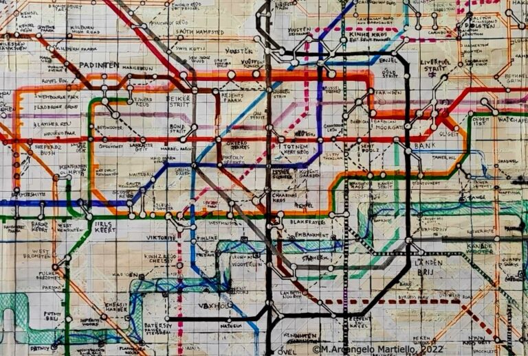
As a tribute to the pioneering works of Harry Beck and Paul Garbutt, who crafted their iconic maps with simple tools, the initial draft was created using colouring pens and paper before undergoing digital refinement. An Improved Depiction of the London Underground Network
The map is structured around the traditional main features of the underground network. The Circle line is depicted with an enlarged and stylised geographical shape, echoing the first Beck map. The horizontal (Central line) and vertical (Northern line) axes feature straight lines reminiscent of the original Garbutt design. The new supplementary axes (Elizabeth line, Thameslink) have been depicted with innovative configurations. These four axes are vital routes for navigating London, requiring clear representations, especially in the central sections. Positioned at the very centre of the map, the visual landmark of the West End "cross shield" of lines provides immediate orientation. 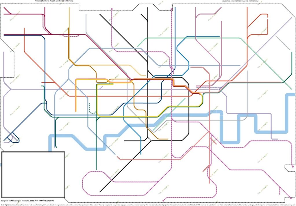
The use of a grid with a fixed minimum distance between lines has resulted in expanded and clearer intersections, improving readability. Additional information such as rail stations, accessibility, and fare zones are presented in a manner that is not visually intrusive.
Mapping Clarity: Eighteen Revisions and Nine Versions
Arcangelo's diagram of lines has undergone regular revisions since the completion of the first digital map (MFNS01) in July 2023. The previous revision (FMNT17), released in February 2026, is the most significant to date. Compared to the September 2025 edition (MFNS16), the diagram was completely redesigned in many areas, using a grid with more rows and columns to enable the creation of a combined Rail and Tube map and to make it as compatible as possible with the Tube-only (i.e., TfL-service) map. 

The current revision (FMNT18), released in March 2026, includes only minor corrections, such as adjustments to the lines between Swanley and Otford, updated step-free access at Colindale, and the spelling of Lloyd Park. Octolinear Tube Maps
From H. Beck to M. Noad: a history of accuracy and simplicity
External Links: the Map on Other Sites
♦ A World Tube Map [FMNT18 (2026/08)/ World] Will Noble, Londonist, 2026 ♦ Alternative London Rail & Tube Map (1933) - Help me to spot any mistakes [FMNT17 (2026/02)/ Rail Connection] r/TransitDiagrams (Reddit), 2026 ♦ Beck's first official London Tube Map (1933) vs Centenary Tube Map (2033*) [MFNS14 (2025/05)/ Centenary] r/TransitDiagrams (Reddit), 2025 ♦ Easy-To-Read Tube Map - April 2025 Edition [MFNS12 (2025/04)/ Easy-To-Read] r/London (Reddit), 2025 ♦ Hottest and noisiest tube line is actually the best during the rush hour - here is why [MFNS11 (2024/06)/ Rush-hour] S Odeen-Isbister, Metro, 2024 ♦ Check out this fantastic Rush Hour Tube Map [MFNS11 (2024/06)/ Rush-hour] Tooting Newsie (Instagram), 2024 ♦ Rush Hour Tube Map... if you wonder where everyone is going [MFNS11 (2024/06)/ Rush-hour] r/LondonUnderground (Reddit), 2024 ♦ If Harry Beck drew the Tube Map today, it will look like this [MFNS10 (2024/05)/ Legacy] r/London (Reddit), 2024 ♦ Easy To Read Tube Map with New Overground Colours [MFNS10 (2024/04)/ Easy-To-Read] r/LondonUnderground (Reddit), 2024 ♦ The Easy-To-Read Map of the London Underground [MFNS08 (2024/02)/ Easy-To-Read] r/TransitDiagrams (Reddit), 2024 ♦ #Notizie da Londra [MFNS04 (2023/09)/ Phonemic] C. Amato, La Mia Vita A Londra (Facebook), 2023 ♦ Chuub Map (Phonemic) [MFNS03 (2023/09)/ Phonemic] Project Mapping, seen October 2023
Easy-To-Read, Rail, World, Legacy, Rush Hour, Respelled, IPA, Phonemic Tube Maps - Copyright © M. Arcangelo Martiello, 2022-2026. All rights reserved. Reproduction in whole or in part, by any means, without prior written permission is strictly prohibited. The only exception is personal, non-commercial use only. Use involving any type of financial gain is strictly prohibited in all cases. Press use: Images may be used for editorial coverage with credit. For all other cases, please contact us using the contact form. Elements of design that are original and have not been previously published are under the copyright of the author. In the event that TfL copyright elements of design are present, they are included for the purposes of non-commercial research, private study, or similar non-commercial purposes. All different versions of this map are a non-commercial educational project and are not for sale. If you encounter these maps available for purchase, please inform us through the contact form. The Subway London Font (used in the Legacy map), and the Paddington Font (used in the Centenary map) downloaded from fonts101.com. The L-IFA phonemic alphabet (used in the Phonemic map) is also an original system created by the author. The information displayed on the maps is accurate to the best of our knowledge as of the date stated on each map. The author is not affiliated with TfL or any of its subsidiaries, and the downloadable pdf files of the maps are not official products of the London Underground.
One Response